[Blog post by Virginia Brussa, SBTF Regional Coordinator for South & Central America]
According to SIGPAD, the second rainy season affected 1,193,956 people of which more than 33,000 were affected in January alone. UN OCHA Colombia requested support from the SBTF in December to map the massive flooding triggered by the second season of rains in Colombia. The SBTF was thus officially activated and interested members of the network were immediately recruited to participate in this joint mapping project.
Some fluency in Spanish was necessary for this project, which posed both a challenge and important opportunity for the SBTF. Some 18 volunteers applied to support the project (including team coordinators) from December 19th onwards. Because of the holiday seasons, some volunteers were not able to remain engaged after applying and getting trained. Nevertheless, and even in spite of the language requirement mentioned above, volunteers came from diverse places: Eliana Zemmer from Italy, Clara Straimer from UK, Catalina Mesesan - Sweden , Idriss Ait-Bouziès - Switzerland, Marta Poblet and Alberto Preato - Spain, Rosa Aguilar - Venezuela, Tom Weinandy and Robin Tolochko now in Bogotá , Colombia. We would like to sincerely thank these SBTF volunteers and coordinators for their great help in supporting all the tasks required to carry out the following processes.
Together, volunteers monitored the media for relevant information as the Media Monitoring Team, approved and mapped reports as part of the Reports Team, geolocated places as part of the Geolocation Team and cross-referenced information as part of the Verification Team.
Specifically, the Flood Crisis Map in Colombia is a product of the Humanitarian Situation Room which comprises an Information Management Team with functions delegated from the Humanitarian Country Team. The Humanitarian Country Team brings together the agencies of the United Nations and the main international NGOs with projects in the country. The map is an effort on the part of different organizations to build and manage relevant flows of information. The objective is to identify emergency needs, responses given and finally assistance gaps.
Work on the crisis map involved visualizing important issues such as access to clean water, health, education, food security, shelter and income generation in different areas throughout Colombia. Floods, landslides and continuous mudslides-results of soil saturation and erosion-often left people isolated and hindered the help of humanitarian teams to the most affected areas. It is therefore important to emphasize the complementing role of information flow offered by this crisis map about these events and needs.
“Focus was given to areas with access problems related to the double impact on communities harmed by natural disasters with the presence of illegal armed groups.” Luisa Pineda, OCHA Colombia Information Coordinator, stressed.

Second winter season: Challenges in the mapping
Mapping was coordinated by Luisa Pineda of UN OCHA Colombia from December through January. She described the complexity of the situation during the rainy season and the new mapping process:
“Colombia has two rainy seasons per year, but during the second half of the rains were prolonged and that rainy season joined with the first half of rainy season. As a result, 27 of the 32 departments were affected by multiple disaster situations with a natural origin, at the time the first phase of deployment was activated in collaboration with various organizations and networks such as Brigada Digital , the Risk Management Office (now National Unit for Disaster Risk Management-UNGDR in Spanish) and the Ministry of Telecommunications.”
“In the new phase of deployment there are involved organizations such as the Humanitarian Studies Institute (HSI), Centro de Estudios Estratègicos Latinoamericanos (CEELAT) , the networks of MinTIC and the SBTF. With protocols adapted for use by the Standby Volunteer Task Force and OCHA from other deployments as the Libya Crisis Map, we activated the Media Monitoring, Report, Geolocation and finally the Verification teams. All teams are coordinated through a Skype chat with an intranet where each team can work on guidelines and specific related documents.”
According to Jeffrey Villaveces, the head of the Information Management Unit in UNOCHA Colombia, the platform ‘Inundaciones’ is being used to spearhead a much wider information management effort on the part of OCHA in the country,
“Our hope is to successfully implement ‘Inundaciones’ for this specific flood emergency, but we are in the process of rolling out an emergency event monitoring platform that is much wider in scope called ‘Monitor’. Using a backend that will systematize events that we already have collected in SIDIH, sidih.colombiassh.org, ‘Monitor’ will allow these events to be visualized hand in hand with Humanitarian Access information, needs evaluations and responses in the field collected using OCHA’s other information processes. In this way, ‘Monitor’ becomes an important information management visualization tool for the humanitarian situation in the country in all of its aspects, integrating existing information management processes with new ones such as those implemented via Skype with volunteers to collect a variety of information. Our hope is to build on this tool to integrate the country’s disparate ‘Observatories’, giving them access to the information collected and systematized to add another layer of value-added with analytical reports.”
These efforts have helped to improve the information quality and the research of the second rainy season in Colombia. Final products are consulted by different humanitarian agencies and national and international organizations. These include humanitarian portals as Redhum with coverage in Latin America, and ReliefWeb, which is consulted worldwide. Both portals are managed by OCHA, the latter example via a network of offices, and the former example from the Regional Office for Latin America and the Caribbean based in Panama.
Our veteran SBTF Report Team Coordinator Eliana Zemmer expands that idea: “I found the map a very useful service that can be accessed by a variety of government organizations and other organizations present on the territory. In a vast country like Colombia it is useful to have a collection of data in a repository because it helps getting a clear picture on the situation and the development can be monitored that way. Useful also in terms of help/relief and of potential and possible actions to take on the ground.”
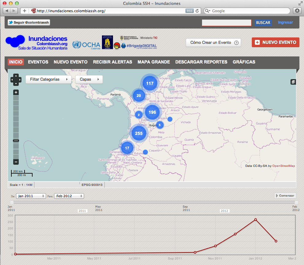
Some data provided to the Floods map through January
As a map of disasters events, this was an interesting exercise because all SBTF members should to take knowledge about the specifics categories of the mapping (example: kind of land- movement), but also about specific issues of Colombia. Some of these were very important to understand what event could be created or approved. ”The approval of report at the beginning created a little bit of confusion for myself not being Colombian example the terms used to indicate specific locations within the city “ said Eliana Zemmer.
Here is some data of the mapping deployment for the second rainy season:
487 reports were created and approved through January 30th,. There are 208 reports on land-movement related events (including events on landslides, mudslides, erosion due to the rainy season). This number represents the 36 % of the total reports generated. In second place, there were 137 reports created related to the flood category (23.7%). Other reports refer to events registered as alerts (12.1%) due to landslides, floods, wildfires and many others for humanitarian response in areas such as food, shelter, education in emergencies, health, water, sanitation and hygiene. It should be noted that, due to the nature of these types of events, land-movements have a higher mortality rate, and generate wider news coverage than flood events, which are gradual rather than sudden, and while very harmful in terms of impact on housing in many regions, generate fewer deaths and hence more limited numbers of reports.
Plurality of events were geolocated in Valle del Cauca department, in second place was the department of Caldas , followed by Cundinamarca (with many of these events near Bogotá-the capital city). Caldas department was widely covered due to a series of dramatic events, including a landslide which killed more than 40. Bogotá generated coverage due to this area being the capital, and the large number of news organizations concentrated there. It should be noted that, per official data, Chocó, Cesar and Magdalena departments were actually more intensely affected and had a larger total affected population than these other locations. However, a very limited news organization presence in these poorer and more sparsely populated areas meant fewer reports were fed into the system. This fact makes it clear that, aside from counting the number of events per se, tracking both official data and the number of affected persons is key to making a platform that fully informs decision-makers.
In this sense, the “shortage” of information about isolated rural areas is a challenge for humanitarian agencies of response, because they need to prioritize their actions under the criteria such as the quality, opportunity and equity and the humanitarian principles of impartiality, neutrality and operational independence.
Considering that scenario consequence of natural events and the media system, Idriss Ait-Bouziès (SBTF volunteer and Geolocation Team Ccoordinator from UNV) added “Colombia is currently facing different kind of disasters,that leads to isolate various locations letting them without any possibility of moving. In that context, our help is more than necessary. Geo-localisation is crucial in such a situation, they need accurate data to be able to deploy aid where it is necessary.We have to learn quickly and be efficient to lighten our workflow so we can deliver exact maps in a short time.”
* Jeffrey Villaveces and Luis Hernando Aguilar (OCHA Colombia- Information Management Officers) have collaborated in this post. Thanks!
2 Comments
It’s a pity you don’t have a donate button!
I’d most certainly donate to this outstanding blog! I suppose for now i’ll settle
for bookmarking and adding your RSS feed to my Google account.
I look forward to new updates and will share this blog with my Facebook group.
Chat soon!
Thanks for your kind words. The SBTF is not an NGO and as such we don’t have legal status to accept funding.
One Trackback
[...] to provide the “surge capacity” requested by the latter; this includes UN OCHA in Libya and Colombia, UNHCR in Somalia and WHO in Libya, to name a few. In fact, these groups even have their own [...]